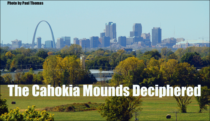
[Editor's Note: While on a cross-country trip, a friend reminded me to look out for some huge ancient mounds that were visible from the highway, slicing through St. Louis, Missouri. Sure enough, I saw them and wondered who could have made them -- and why? While the traditional answer is that they were some burial tomb of an ancient American Indian tribe, there was little evidence to support this. Many smaller mounds appear to be part of this same complex. One of the smaller mounds can be seen in the foreground of this amazing photo, showing the St. Louis skyline. Thanks to researcher, Martin Doutré, we now have solved this mystery.]
THE CAHOKIA MOUNDS DECIPHERED.
 ne of the perplexing questions posed by early settlers in North America was, why would local Indian tribes, observed to be mostly hunter-gatherers, build the huge mound complexes found scattered across the eastern and central States of the continent.
Some mound clusters, like the Cahokia group at Collinsville, Illinois, numbered in excess of 120 individual structures, with yet another vast set only 7-miles away on high bluff's above the Mississippi River. This second set of mounds to the West, in what became Old St. Louis township, sat conspicuously within view from an observer's position atop huge "Monk's Mound" of the Cahokia set, with far-off "Big Mound" dominating the distant western skyline.
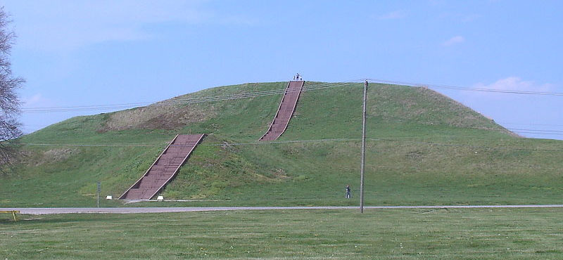
[ Above: Monk's Mound, Collinsville, Illinois is the biggest purpose-built structure of ancient North America, with base dimensions considerably larger than Egypt's Great Pyramid.]
Moreover, the Cahokia mounds were, predominantly, very big structures, which meant that the commitment to build them is difficult to even contemplate.
Monk's Mound alone is said to contain 22,000,000 cubic feet of hard-packed earth and the combined volume of the many smaller, satellite mounds, extending out from it to every side, would more than double that figure.
Putting this into perspective, it would take a reasonably large work-force of say, 1000-people digging, carrying and compacting, say, 10 baskets-full of earth a day (weighing 55 lbs each), four full years (without a day off) to build Monk's Mound. The fact that the nearest "borrow-pit", from which the earth was acquired, was over half a mile away would make the 10 loads per day, per worker, difficult to achieve.
In addition, there are the other 120 or more smaller mounds of the Cahokia group, some of which sat up to 1.5-miles away. One then has to further consider that there were thousands of mounds built, as well as massive geometric earth embankment complexes, across North America.
It goes without saying that this was a very ambitious project that cannot be attributed to a despotic, powerful Indian chief wanting his own set of lofty, tailor-made hills to stand around on as symbols of his status.
Politically Correct?
This and other equally implausible explanations are proffered by politically-correct archaeologists and historians who currently dare not suggest that the mounds could have been built by anyone other than recent-era Indians.
In the 1960's & 70's everyone knew that the mounds were built by a "lost-race" of enigmatic "Mound-builders" 5000-years ago, but in recent decades our modern-day, mainstream academics seem to have, conveniently, mislaid about 4000-years of North American history. In keeping with their PC obligations, they deceptively lure or cajole us into accepting that Cahokia "got-up-and-running" in 1000 AD as a great Indian metropolis, and this is what we and our school-children are indoctrinated into believing. To suggest otherwise is now considered to be shameful and even "racist".
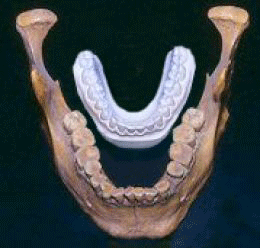 Of course there's no mention of the fact that many large stature skeletons were exhumed from the mounds during the 19th century especially, and gifted into the collection of the Smithsonian Institute, never to be seen or heard of again. These skeletons differed markedly from the physiology of the Asiatic-Indians
and, where hair was still present, it was often red or blond in coloration.
Of course there's no mention of the fact that many large stature skeletons were exhumed from the mounds during the 19th century especially, and gifted into the collection of the Smithsonian Institute, never to be seen or heard of again. These skeletons differed markedly from the physiology of the Asiatic-Indians
and, where hair was still present, it was often red or blond in coloration.
See: www.xpeditionsmagazine.com/.
The reason for mound-building, district-by-district, becomes clear when the individual positions of each mound are subjected to proper surveying analysis. It should have long-since dawned on our archaeologists that each structure is a precisely placed survey-marker, residing at a coded distance and angle from a central fulcrum or hub mound.
In the Cahokia group, the centre-top of Monk's Mound is the benchmark hub or preeminent surveying station, back to which all outlying mounds relate.
An Ancient Navigation School
The reason why the Cahokia complex was sited at that geographical location is because it's very near to where the confluence of the Mississippi and the Missouri rivers occurs, allowing for very navigable river highways extending from the North Atlantic Ocean through the St. Lawrence Seaway and Great Lakes to Minnesota, then, down the Mississippi River to the Gulf of Mexico. The Missouri River extends from Montana to St Louis and a multitude of tributaries branching from these two grand river systems provided waterway access to vast stretches of North America.
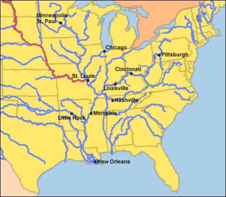
East of the Rocky Mountains, there was no centre in Middle-America of greater strategic importance than where the two great rivers combined near St. Louis, Missouri.
It's very evident that many Bronze Age ships made the North Sea crossing from the Orkney and Shetland Islands, via Iceland, Greenland and Newfoundland at the mouth of the St. Lawrence Seaway, in order to mine copper in the Great Lakes region. It's estimated that at least 500,000 tons of copper (some estimates are considerably higher) were removed at places like Isle Royale and all of it left North American shores.
Thousand of ancient mine workings still exist on the Canadian North Shore of Lake Superior and the Keweenaw Peninsula of Michigan, where copper that was 99% pure could be extracted straight out of the ground and shipped without refinement.
Whereas much of the copper obviously found its way to the British Isles, Continental Europe and the Mediterranean via the St Lawrence Seaway and North Atlantic, other bulk quantities were taken to South America via the Mississippi River outflow into the Gulf of Mexico.
 The evidence suggests that a great preoccupation of the Bronze Age epoch was the shipping of copper ingots from North America back across the Atlantic to feed the huge demand for bronze weapons and utensils. Nations with bronze had a district military advantage over those that didn't and trafficking in the constituent metals of copper and tin assumed tremendous importance until the onset of the Iron Age and the advent of steel weapons.
The archaeological evidence clearly shows that the oldest skeletons, structures, cultural symbolism, language & incised writing forms or artefacts, etc., in North America, stem from the European and Mediterranean theatres to the East and not down the West Coast from the Bering Sea crossing-point into America from Asia, where the Asiatic-Indians originated. The great cities of South America, built according to ancient Mediterranean/ European measurement standards, mostly predate the influx of conquering Asiatic Indians into South America.
To successfully traverse the Atlantic with their precious cargos, Bronze Age mariners needed to be able to navigate very accurately and do precise positional plotting at sea, which was the whole purpose of the Cahokia Mounds open-air-university. In reality, The Cahokia school is no different to similar schools at Brodgar Ring in the Orkney Islands, Durrington Walls Henge in Southern England or Avebury Henge 20-miles to its North, as well as schools throughout Continental Europe and the Mediterranean or Nazca in Peru and Easter Island in the Pacific. All taught the same parcel of factorable scientific numbers to student navigators, using the same distance and angle tutorials and measurement standards on each site.
The key fact that our archaeologists and surveyors need to know in order to decipher these ancient sites is:
The so-called British Standard inch and foot are very ancient and all the "feet, cubits, reeds or miles", including cubic-inch volumes used in the well-known metrology standards of ancient Mediterraneans/ Europeans, are founded upon the same inch still used in the United States today.
So, let's apply that archaic measurement standard, as well as the (circa 4000 BC) Sumerian 360-degree angle system, to the Cahokia Mounds complex to see a sampling of the very familiar, old world numbers generated. (Note: All decimal tails on numbers herein are very simple fractions, easily within the capabilities of ancient mathematicians to calculate.)
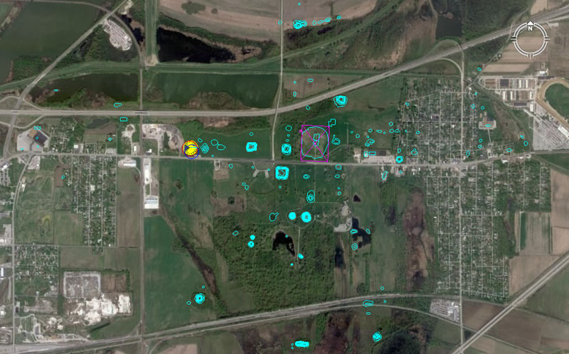
In this picture the Google Earth image of Collinsville, Illinois is overlaid with an electronic map, showing the known, precise positions of 104 mounds of the Cahokia group. A yellow spoked circle shows the position of Woodhenge and Monk's Mound is encased within a slightly offset purple rectangle.
The dimensions of that rectangle are based upon Reed's 1968 solid-core survey to determine the exact (original or intended) design dimensions of Monk's Mound. Each outlying mound, standing at a measured distance and angle from the hub position atop Monk's Mound, was a classroom in its own right and contained very important codes of position, essential to the knowledge-base of students of navigation and cyclic astronomy, learning their craft at Cahokia.
The above mound positions are taken from the University of Wisconsin, Milwaukee Map, made after extensive research into the former positions of many now eradicated mounds. The detailed survey is found in The Cahokia Atlas, A Historical Atlas of Cahokia Archaeology, by Melvin Fowler.
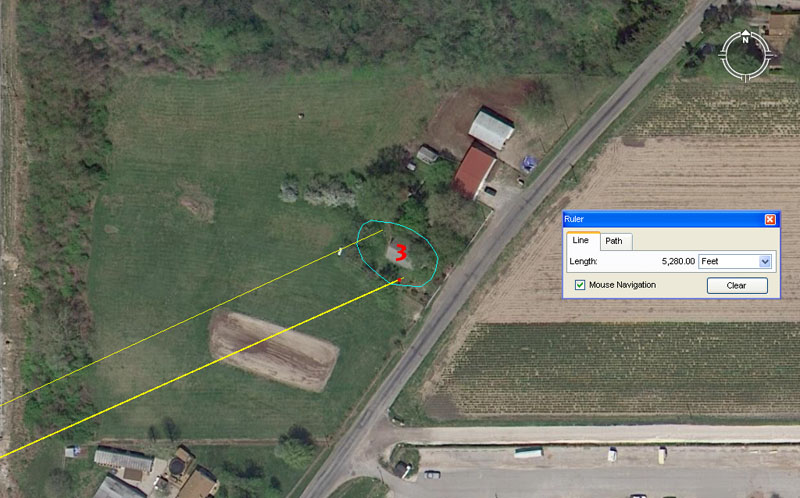
Mound 3 has a house built on it and sits exactly 1-mile (5280') from the centre of Monk's Mound at an angle of 66-degrees
(Note: the ancient chain was 66' and the furlong or furrowlong was 660'). A second coded angle, falling onto the mound, relates to the equatorial circumference of the Earth and these same values recur on ancient British mound-marker sites dating to 3000 BC.
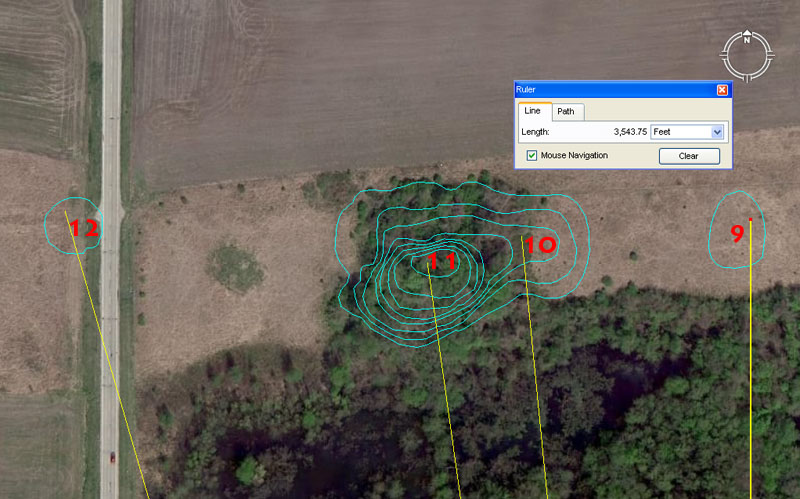
Mounds 9 to 11 contain cleverly encoded distances and angles.
Mound 9 sits due North of Monk's Mound hub at a distance of 3543.75'. For ancient students setting up their manual theodolites (alidade sighting tables and rules) at the fulcrum position atop Monk's Mound, Mound 9 (although now very dilapidated) provided orientation onto true North.
The distance value is dynamic and one of the big numbers of antiquity relates to the 354.375-day lunar year. It is obligatory that this value be found on the large, open-air-university sites and at Avebury Henge in Southern England it was cleverly encoded into the distance from the giant obelisk position within the Henge to the doorway of West Kennet Longbarrow. That distance was 7087.5' (2 X 3543.75') for a return angle of 354.375-degrees.
Mound 10 at Cahokia sits 3543.75' from the Monk's Mound hub at 354.375-degrees, which so closely parallels the Avebury Henge methodology as to suggest a direct link between the design-architects of both sites.
And in similar fashion, very "in-your-face" coding has been built into the next mound in the lineup:
Mound 11 sits 3520' from the Monk's Mound hub at 352-degrees.
The sum of 3520' is 2/3rds of a mile of 5280'.
The 352 value sets up a mathematical progression much used in calculations within the "11" family of numbers navigational system and 352' is 1/15th of an English mile.
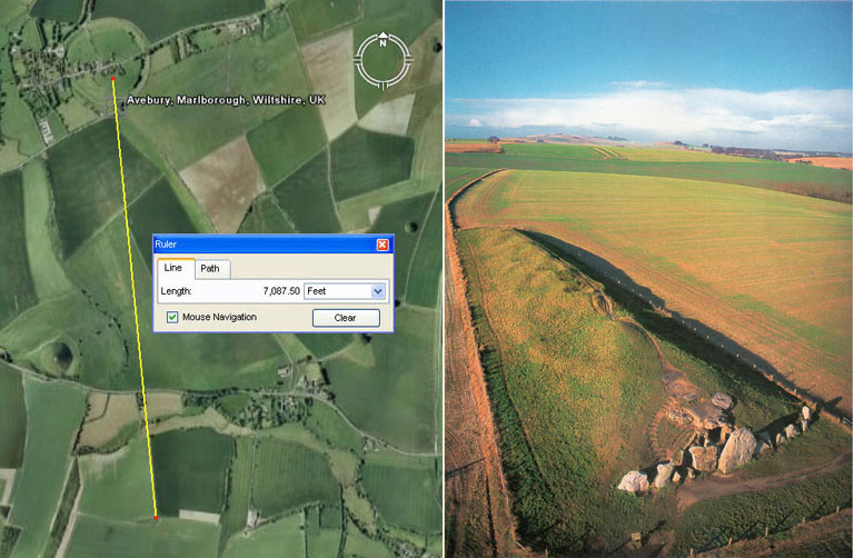
The very important codes related to the lunar year and Egypt's Khafre Pyramid base dimensions are found in the distance and angle relationship existing between Avebury Henge's centre obelisk position and the doorway into West Kennet longbarrow (Southern England). The distance was set to 7087.5' (2 X 3543.75') and the return angle from the doorway to the obelisk was set to 354.375-degrees.
Very similar coding was incorporated into positions at Cahokia with the distance and angle between Monk's Mound hub and Mound 10 ... 3543.75' @ 354.375-degrees.
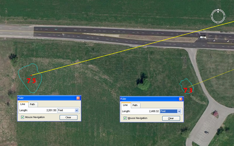
The same doubled-up coding occurs in the very important positions of mounds 73 & 75.
Mound 73 sits a coded distance of 2488.32' from the hub position on Monk's Mound @ an intended azimuth angle of 248.832-degrees.
This mirroring of distance and angle is in homage to the 24883.2 mile equatorial circumference, which ancient mathematicians described in factorable numbers as, 12 X 12 X 12 X 12 X 1.2 miles.
Mound 75 sits a coded distance of 2551.5' out from the hub atop Monk's Mound @ 255.15-degrees.
This mirroring of distance and angle accentuates the 2551.5-day period (7.2 lunar years of 354.375-days each) monitored alongside 2556.75-days (7 solar years of 365.25-days each) in the ancient lunisolar Sabbatical calendar.
The Sun and the Moon
Ancient astronomers needed a calendar system that followed the periods of the Sun & Moon on a daily basis, but there was a major problem to overcome. With the solar year @ 365.25-days and the lunar year @ 354.375-days, the discrepancy between the two periods was almost 11-days. Trying to create a mathematical system that could fluidly and easily accommodate both cycles posed considerable difficulty. It was observed, however, that 7-solar years was almost the same as 7.2-lunar years. The difference was only 5.25-days, so ancient mathematicians then devised measurement increments based upon 5.25 to deal with this. They created a reed of 10.5' (2 X 5.25'), a short stadia of 525' and a mile (based upon the number families, "6&7" combined) of 5250', which much later in history was adopted by the Greeks.
Under their system, the solar and lunar periods could then be counted off in increments of 5.25-days. The sum of 486 X 5.25-days was 7.2 lunar years or 2551.5-days, whereas 487 X 5.25-days was 2556.75-days or 7 solar years. The astronomer-mathematicians then devised a system wherein, on the sixth day (5.25-days is into the sixth day) after starting the solar count, they would have an auspicious ceremony and start the lunar count (culling sprigs of mistletoe from a venerable old oak tree, while other savant-astronomers danced around the tree singling "Hey Derry-Derry Down", etc.). Thus by starting the lunar count 5.25-days after the solar count the periods for both Sun & Moon ended on the same day 2551.5-days later. This was the very successful and accurate lunisolar Sabbatical Calendar system.
We see here at mound 75 site just how important the value 2551.5 was to ancient astronomers, who double-coded it into a dedicated site so that the value could never be forgotten.
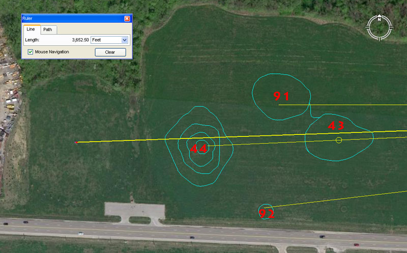
To the left side of the picture the circular aspect of Cahokia's Woodhenge post circle can be vaguely detected.
Woodhenge's centre post sits 3652.5' from the hub position atop Monk's Mound at a return azimuth angle of 88-degrees.
The distance is in homage to the 365.25-days in a solar year. The very clever way in which the ancient astronomers set the centre post of Cahokia's Woodhenge circle, meant that first glint of the equinoctial sunrise on Monk's Mound would be observed where the base of the 3rd terrace met the top of the 2nd terrace. This notch on Monk's Mound sat very close to 91.3125-degrees (91 5/16ths) and the sum of 91.3125-days is 1/4th of a solar year of 365.25-days or 1/2 of 182.625-days (182 5/8ths) ...the number of days between equinoxes.
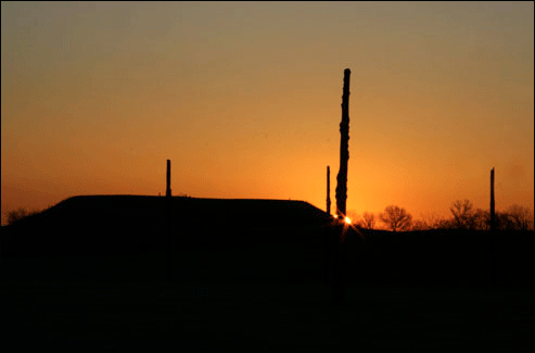
From the centre post of Cahokia's Woodhenge. the Sunrise on the day of the equinox was coded to represent 91.3125-degrees (91 5/16ths) azimuth as the rise position on Monk's Mound. (Photo by Scott McNealy).
MEANWHILE, ACROSS THE MISSISSIPPI IN OLD ST. LOUIS
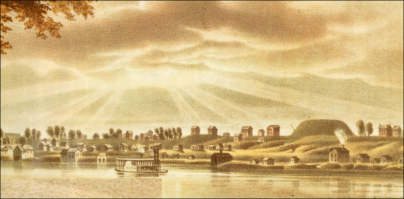
The beautifully symmetrical outline of Big Mound dominated the high bluffs above the Mississippi River when St. Louis was first settled and built. Directly South of Big Mound was a cluster of satellite mounds, including one visually spectacular structure in three tiers or levels.
Picture: View of St Louis landscape from the northeast in 1840. Lithograph by John Caspar Wild (Missouri Historical Society collection).
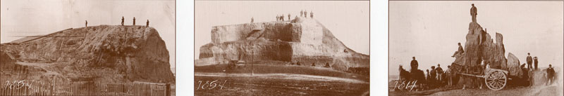
Now you see it ... Now you don't.
The ancient, purpose-built hub position of Old St. Louis, out from which many satellite mounds (bearing special distance and angle tutorials) were precisely positioned.
The hub atop Big Mound sat 35640' (exactly 6.75-miles of 5280' each) from the hub position atop Monk's Mound, at an azimuth angle of precisely 260-degrees (return angle 80-degrees). Pictures taken from a poster publication of the Missouri Archaeological Society, September 1998.
The Cahokia Mound's complex is easily deciphered, simply by knowing the precise spots where each mound sat. With the positions of 104-mounds now fixed, the ancient open-air-university can still function very adequately in teaching students the numbers needed for two ancient systems of navigation and positional plotting or dead-reckoning at sea (one based upon the mile of 5250' and the other based upon the mile of 5280'). Also, the codes-of-position for the mounds are sufficiently intact to teach how the ancient lunisolar, Sabbatical Calendar worked, as well as how 3 major lunar cycles were monitored and calculated.
Of course, in running the school these days, we might find ourselves standing around inside someone's private house built atop a former mound, which wouldn't be so bad as long as there was plenty of beer in the fridge.
To see all of the ancient in-built codes that can still be extracted from over 130 mounds between Collinsville, Illinois and nearby St. Louis, Missouri, go to: http://www.celticnz.co.nz/Cahokia/Cahokia1.htm
Martin Doutré, July 2011. ©