Our excellent online 70-648 Certification dumps and 70-573 exam Certification will lead you to success in the testking 70-523 certifications. We also offer latest exam oracle 70-519 guide and HP0-J48 Certification training dumps with 100% success guarantee.
An Examination of MGS imaging data for MOC Image m1501228b.
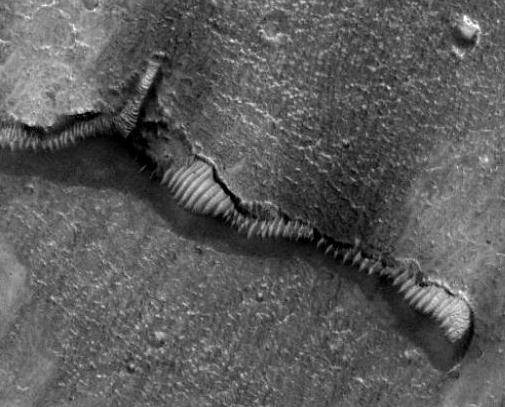
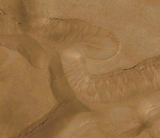
In this effort we will attempt to assess the validity of imaging data relating to the purported entrance to the "Martian Glass Tunnel System" which was posted on Johnny Danger's Dangerous Mars Site. As other credible researchers have speculated profusely on the nature of these "tunnel like\tubular anomalies" we will not re-iterate their notions or add to the confusion with additional conjecture (however, some degree of speculation is inevitable due to the subject matter). Our intent is to examine the MGS ancillary data related to the imaging of this area on Mars as well as utilize several image analysis techniques in an attempt to discern the true nature of this unusual image and several geographically adjacent anomalies found in the vicinity. I heartily recommend downloading these images and viewing them with a decent viewer or imaging program such as Photoshop, as utilizing a web browser for their perusal is inadequate. I would also recommend viewing them on a high resolution monitor (CRT) rather than a laptop. The original source for the image under analysis is MOC m1501228b . I will further preface this analysis with this disclaimer. I am a layperson who has, as a hobby, taken an interest in Martian anomalies. It has been very educational as well as entertaining. I am not a professional scientist, educator or imaging expert. I will not benefit from any financial gain as a result of the dissemination of this information. That being said, I've done my best to utilize the God given natural ability and talent I've been blessed with to understand and analyze this data in a thorough and impartial manner (with an enormous amount of help from others for which I cannot adequately express my appreciation). Any errors or omissions are the results of this authors unfamiliarity with this "rocket science" and are not a deliberate attempt at duplicity. I merely seek the truth and a better understanding of the universe we exist in. Readers may wish to read our earlier analysis of MOC image m1501228d which addresses the apparent dichotomy between "Martian Dune Trains" and "Martian Glass Tunnel Anomalies". First let's revisit an image from our last installment. Shown here is an actual Martian dune train image from the Malin Space Science Systems image repository. A link to the original image is provided below.
[source: www.msss.com/mars_images/moc/june2000/gorgonum/gorgonum2_c100.jpg]
The Anomalous Image
Image Enhancements by Eric C. Lausch

Image Enhancements by Kevin Klettke and Eric C. Lausch
Spacecraft Data Table 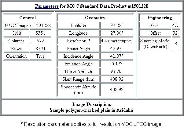 Mars Global Surveyor Parameter Descriptions
Interpreting the data for MOC Image m1501228b
The incidence angle (42.87) is the angle of the sun from directly overhead. The complement (about 47 degrees) is the elevation angle above the horizon. The azimuth is 298.93, which means that the sun is about 29 degrees to the right of the top of the image. Basically, the image is illuminated from the upper right. This is helpful because it allows one to reasonably extrapolate or interpret the formation of shadows for a three dimensional construct this scope. Now let's look at Emission angle, Slant range and Spacecraft altitude as a single entity. The Emission angle is 0.17 degrees and is (I assume-correct me if I'm wrong here) a function of Slant angle and Spacecraft altitude. As the Slant angle and Spacecraft altitude are both listed as 408.92 Km the spacecraft was directly overhead at the time of imaging. (Another assumption-the small emission angle is the product of rounding errors or truncated decimal values of the aforementioned parameters-thus it's not equal to zero.) This virtually eliminates the possibility of pixel stretching or optical illusions incurred by imaging done at an oblique angles. Resolution and it's pertinence is discussed below in the physical dimensions section. Clearly, under the given imaging conditions, one can virtually eliminate the the possibility that this is a "trick of light and shadow" (TOLAS). In layman's terms, "What you see is what you get".
The resolution for this image is 4.47 meters\pixel. By utilizing an imaging program, such as Photoshop, we can count the number of pixels in height and width of a particular feature and multiply that number by 4.47 to estimate the approximate size in meters of the feature being analyzed. At a scale of 4.47 meters\pixel a quick pixel count in Photoshop yields a height of approximately 74 pixels (top of Forehead) by a width of approximately 41 pixels (width of humanoid head). This translates to approximately 331m high by 183m wide (1085 feet by 600 feet). The overall distance from the "water" to the top of the head is approximately 1920 feet. The entire anomaly (humanoid and fish sculpture) is approximately 131 pixels high by 88 pixels wide or 585m by 393m(1920ft by 1289ft). That would make this edifice around three eighths of a mile high! A construct far larger than either Mt. Rushmore and Crazyhorse in South Dakota or Stone Mountain in Georgia.
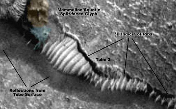
Image Enhancements by Kevin Klettke and Eric C. Lausch
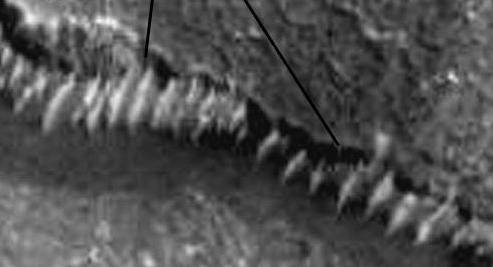
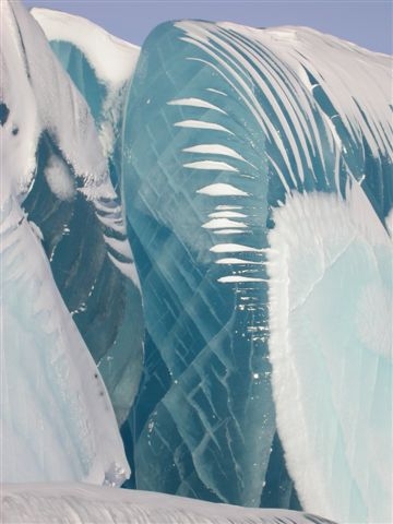
Image Enhancements by Kevin Klettke and Eric C. Lausch This author, for one, cannot fathom the reasoning behind such a lack of scientific curiosity. After reviewing all the facts and data in regards to Mars anomalies I can come to no other conclusion than that these organizations for some reason do not examine the claims of Martian anomalies in a disciplined scientific manner when these unusual artifacts are presented by individuals outside of the Planetary science community. (It seems almost to be a threat response-fight or flight-when someone who is not a member of their exclusive club plays a trump card that they cannot counter). What possible impetus drives these organizations to dismiss out of hand or ignore the queries of the American taxpayer, who in effect, pays their salaries? It defies the very nature of noble ethics, good will and common sense that this nation was founded upon. UPDATE: The following images were sent by George Chittim from Vancouver who observed the same phenomenon here on Earth. He states, "The tubes are actually ice. I suspect we are seeing the exposed edges of frozen oceans covered by sand. Here are some pics of ice on Earth with the same characteristics." They sure look the same... thanks George. 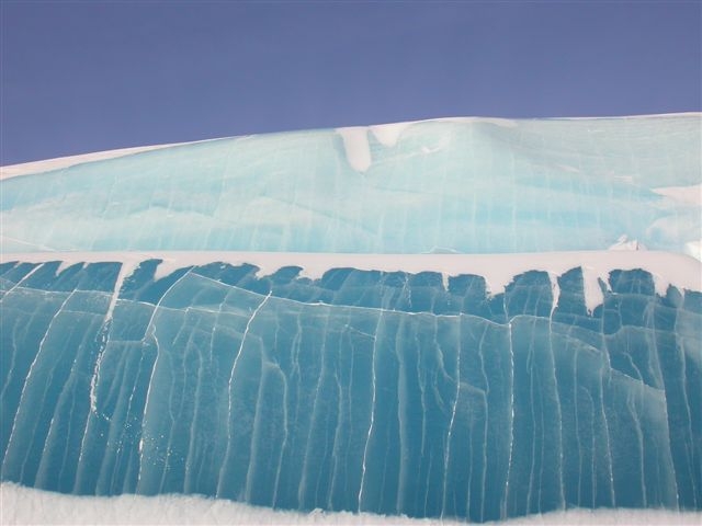
|