
 The Celestial Desert: Arizona Star Map Update © 2002 by Gary A. David. All rights reserved In the article "Carving the Cosmos: An Arizona Star Map in Stone" recently published in the online journal ViewZone, I described a petroglyph panel about 25 feet long and 15 feet high located near Homolovi State Park in Winslow, Arizona. That article showed in great detail the staggering complexity of light and shadow playing across the vertical sandstone surface. For instance, at a little after noon on the summer solstice a triangle of light enters a carved spiral, much as it does at the more famous marker on Fajada Butte in Chaco Canyon, New Mexico. I also identified a number of constellations in this rock art: Orion, Sirius in Canis Major, Canis Minor, Gemini, Auriga, Taurus, and the Pleiades. Thus, the petroglyph panel represents both the solar and the sidereal. In addition, the previous article described a pattern of Hisatsinom (either Anasazi or Sinagua) and Hopi pueblo sites that correlates to every major star in the constellation Orion. For instance, the three Hopi Mesas correspond to the belt stars in much the same manner as the Egyptian pyramids at Giza. The first section of this present article will explore some new information about the Arizona petroglyph panel, and the second section will provide geodetic correlations for both Taurus and Aries in the American Southwest.
Dating the Cosmos
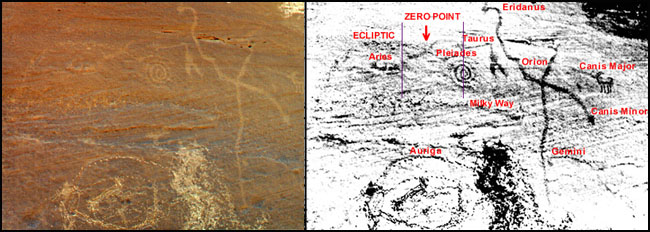 For the purpose of review, from right to left we see that the antelope petroglyph represents Sirius, whereas the oblique line (what I call the "plumed serpent") intersecting with the vertical line represents Orion. (See petroglyph panel with constellation names in red.) Adjacent to this is located the down-turned V-shaped artifact, which clearly represents Taurus. Farther to the left is the counterclockwise spiral which correlates to the Pleiades. In addition, below the equilateral cross of Orion are two natural cupules, one in which a mark has been artificially abraded; these represent Castor and Pollux in Gemini. To the left of this constellation we can also see the carved glyph of what I call the "corral," corresponding to Auriga. Finally, the creators of this rock art used a natural groove cutting horizontally just above the top of Gemini to represent the galactic plane of the Milky Way. I have also described a long abraded line that starts at the lower left of the panel and arcs upward to end in the spiral. This line which I originally said was symbolic of an ancestral migrational path might actually serve another purpose. The Ancients could undoubtedly see the curving path of the Sun, Moon, and planets across the night sky. We call this loop the ecliptic, upon which the signs of the zodiac also proceed from east to west. In addition, we designate the point where the ecliptic crosses the celestial equator (the Earth's equatorial plane projected into space) as the zero point, from which right ascension (celestial longitude) is calculated. Because of the effect of precession, this point measured from the vernal equinox sunrise shifts backwards, or precesses, along the ecliptic one degree every 72 years. The total precessional cycle equals 25,920 years. What we call the First Point of Aries is now located between the constellations Pisces and Aquarius; thus, we are entering the Age of Aquarius. In my initial analysis of the petroglyph panel I overlooked a horizontal mark in the rock panel to the left of the spiral. Due to its proportional relationship to the spiral (the Pleiades) and the other constellations, this could very well represent the constellation Aries. In addition, the long abraded line located above the petroglyph of Aries could plausibly be conceptualized as the ecliptic. The line ends at the spiral of the Pleiades, whereas the ecliptic itself passes within only four degrees or so of the constellation. On the petroglyph panel an additional line had been carved from the notched end on the left of the horizontal extension of Taurus, arcing downward to join the right side of the horizontal line of Aries. This line intersects the abraded line (ecliptic) at a little more than half the distance between Taurus and Aries. Did the Ancient Ones who carved this petroglyph panel mean to point to this specific spot on the ecliptic as a time marker? If so, they were indicating a date of approximately 1000 BC. In my previous article I stated that these petroglyphs were probably incised about the time that the nearby village (known today as Homol'ovi I) was established, circa 1260 AD. Why, then, would this rock art refer to a date 22 centuries earlier? Were the petroglyph makers in actuality putting a copyright date, so to speak, on their creation? This sort of artistic individuality, of course, probably did not exist, but the petroglyph carvers may have wanted to indicate this approximate date for astro-spiritual purposes. During this same period about three millennia ago, the Hopi language gradually distinguished itself from the other members of its Uto-Aztecan family. "The linguistic evidence indicates that the forebears of the Hopi separated from their Numic congeners, and 'came out' of the Great Basin around 1,000 B.C..." [Richard Maitland Bradfield, An Interpretation of Hopi Culture, p. 391] This date is squarely at the center of the Age of Aries. Were the carvers of this cosmology trying to tell their descendants (as well as us) the time frame of their arrival in this region of northern Arizona?
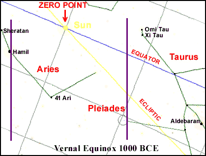 Rock art has been dated with only minimal success, using cultural style or degree of patination as guides. (Patination is the relative weathering and oxidation of a stone surface that makes it appear darker than underlying surfaces that have not been exposed or carved into.) However, if we do indeed have a sidereal map that shows the ecliptic with an "X marking the spot" of the precession of the equinoxes during that era, then the petroglyph panel can be confidently dated within a span of no more than about 500 years. Looking at a star chart for sunrise of the vernal equinox in 1000 BC, notice the apparent distance (not the actual light-year distance) between Xi or Omi in Taurus (both magnitude 3.8) and Hamal in Aries (2.0 --the smaller the number, the brighter the star). This is proportional to the distance between the leftward extension of the Taurean V-shaped artifact and the right side of the Ariean horizontal petroglyph. Furthermore, the distance between the two stars in Taurus and the zero point (the ecliptic crossing the celestial equator) as well as the distance between Hamal in Aries and the zero point are both proportional to the corresponding carvings on the petroglyph panel. In my previous article I stated that at sunrise "the eastern wall of the enclosure begins to cast a gently arcing, horizontal shadow" upon the petroglyph panel. At the point where it crosses the ecliptic line, this shadow may represent the celestial equator. Specifically, the right side of a slight convex bump in the shadow occurs precisely at the spot where the ecliptic crosses the dividing line carved between Taurus and Aries. If this shadow can indeed be construed as representing the celestial equator, then the Ancients had a firmer grasp of celestial mechanics than heretofore suspected. This presupposes that so-called "primitive" humans knew that the earth was a sphere, as some independent researchers have suggested. (For example, Crichton Miller in his recent book The Golden Thread of Time. Also in the same volume, see my essay "The Orion Zone: Ancient Star Cities of the American Southwest.") If the petroglyph panel was indeed carved three thousand years ago, that date was long before the pueblo villages were settled in a pattern to reflect the constellation Orion. The typical mode of habitation prior to the 11th century AD was not the pueblo but the semi-subterranean pithouse decentralized upon the desert landscape. Nonetheless, the constellations were spiritually significant enough to be depicted in a stone chart. Perhaps at this early time the Ancient Ones first realized the hermetic maxim "as above, so below" and began to find terrestrial correlations to the sky beings. Many centuries before the pueblo villages were constructed, these locations functioned possibly as pilgrimage sites, shrines to honor the celestial deities brought down to Earth. It is this sort of non-pueblo demarcation that we find associated with two other constellations in the American Southwest. Taurus and Aries Correlations
 Although many cultures around the world have associated Taurus with the bull or wild ox, this zodiacal constellation was also universally connected with the concept of water. In fact, the Greek word Hyades (an open cluster representing the face or perhaps the horns of the bull) means "to rain." Farmers and mariners have always recognized this group of stars as a sign of coming storms and precipitation. Ovid calls them Sidus Hyantis, or "Rain-Bringing Stars." The Hyades --half-sisters of the Pleiades-- apparently were stricken with grief after their terrestrial brother, Hyas, drowned in a well; thus, their copious tears of mourning became rain. [Julius D.W. Staal, The New Patterns in the Sky: Myths and Legends of the Stars, p. 76] Consequently, the influence of Taurus is especially crucial in the desert where one's survival is totally dependent upon the presence of this inconstant element.
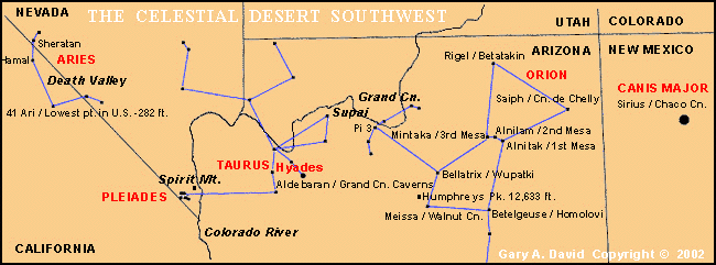
The association between Taurus and caverns makes perfect sense when we remember the exquisite paintings of bulls found in the caves at Lascaux, France and Altamira, Spain. Near the entrance of the former complex is a naturalistic rendition of a bull, above which are suspended six dots. Some hypothesize that these represent the six visible stars of the Pleiades. If so, this would mean that Upper Paleolithic humans associated male bovines with the constellation Taurus about 16,500 years ago-- at least 12,000 years before the zodiac is thought to have been conceived! [David Whitehouse, "Ice Age star map discovered," 9 August 2000, BBC News [online]. In addition, the bull-obsessed Minoan culture of Crete kept its bull monster, the Minotaur, inside the dark recesses of the Labyrinth, which reflects the twisting, intestine-like passages of cave systems. Where, then, on a map of the Southwest is Aries located? Moving a proportional distance in a westerly direction from Orion, Taurus, and the Pleiades, I found that Terra Aries rested snugly within the contours of Death Valley, with the stars Sheratan and Hamal to the north near the Grapevine Mountains (not to be confused with Grapevine Canyon at the very southern tip of Nevada) and 41 Aries to the south. Because this is a territory of nomadic rather than sedentary habitation, no pueblo ruins exist, though petroglyph sites suggest the stars of this constellation in its mundane manifestation. In fact, petroglyphic evidence of the Ram abounds in this region. According to David S. Whitley, one of the foremost experts on North American prehistoric art and a professor of archaeology at UCLA, the Coso Range just south of Death Valley National Monument is... "One of the most spectacular concentrations of rock art sites in North America--if not the world..."! [David S. Whitley, A Guide to Rock Art in Southern California and Southern Nevada, pp. 49-52] Along this thirty mile stretch of canyon located within the boundaries of the China Lake Naval Weapons Center, over 14,000 pecked rock drawings are known to exist. [Robert F. Heizer & C.W. Clewlow, Jr., Prehistoric Rock Art of California, Vol. 1, p. 21] Dr. Whitley claims to have found over 350 engravings of bighorn sheep alone, which he estimates to be between 1,000 and 1,500 years old. [Whitley, op. cit., p. 50] Whitley believes that this plethora of sheep petroglyphs formed part of a shamanistic ritual system to induce rainfall.
"Since the shaman and his spirit helper, the bighorn sheep, were considered one and the same, and since the shaman's trance was a metaphoric form of ritual death, the shaman made rain by 'killing a bighorn' (or killing himself, a supernatural bighorn) and entering a trance. Thus, petroglyphs depicting a human shooting a sheep have nothing to do with hunting; they are metaphoric symbols indicating that a Bighorn Shaman came to this location and entered a trance to bring rain." [Ibid., p. 49]These shamans sometimes traveled great distances on their vision quests. Whitley states that Numic speakers (i.e., Shoshone, as well as Northern and Southern Paiute, all of which belong to the same language family as the Hopi) may have traveled even as far as Wyoming's Bighorn Basin (its name merely another coincidence?) to obtain power in warfare. [Ibid., p. 9] They might have also been attracted to both the world's largest mineral hot springs at the present town of Thermopolis and the Bighorn Medicine Wheel. Incidentally, the latter site is located on precisely the same meridian as Chaco Canyon, the largest pueblo site in the Southwest, whose celestial correlation I have elsewhere identified as Sirius in Canis Major, the brightest star in the heavens.
The early shamanistic tradition of associating mountain sheep with rainfall is carried on in the Pong (Pang), or bighorn sheep katsina (kachina), which in particular has the power to make rain as well as to cure spasms. [Barton Wright, Hopi Kachinas: The Complete Guide to Collecting Kachina Dolls, p. 102] The Hopi word for the bighorn sheep is pangwu, or pa'ngwu. Breaking up this word, I found that pa (paa) denotes "water," but it also has the sense of "wonder, awe, surprise," etc. The suffix ngwu means "causing to occur." Thus, pa'ngwu literally means "causing water (or in the desert, 'wonder') to occur," which points to the mountain sheep's shamanistic potentiality.
In this article I have suggested an earlier date for the carving of the Arizona star map in stone, which demonstrates the Ancients' knowledge of precession of the equinoxes. I have also extended the configuration of the sky-ground Orion correlation to include the adjacent constellations of Taurus and Aries. Co-authors Giorgio de Santillana and Hertha von Dechend in their scholarly tour de force entitled Hamlet's Mill discuss the sidereal terms of the Platonic cosmology found in the Timaeus. "When the Timaean Demiurge had constructed the 'frame,' skambha [Sanskrit word for axis mundi, or world center], ruled by equator and ecliptic--called by Plato 'the Same' and 'the Different'--which represent an X (spell it Khi, write it X ) and when he had regulated the orbits of the planets according to harmonic proportions, he made 'souls.'" [Giorgio de Santillana and Hertha von Deschend, Hamlet's Mill: An Essay Investigating the Origins of Human Knowledge and Its Transmission Through Myth, p. 306] Hence, the process of soul-making includes the human recognition of an X which marks the spot of the vernal equinox sunrise along the planetary path. From this we may conclude that such knowledge of our cosmos as it shifts through time paradoxically grants us immortality. In this case, knowledge is much more than mere mundane power rooted in the earth. It is instead dispersed in the spirit-winds incessantly blowing across the celestial desert.
|
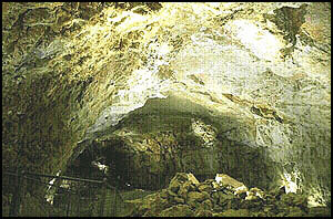 Aldebaran, the bloody bullseye of Taurus, has its specific Arizona correlation in the eponymous Grand Canyon Caverns. (See map.) Located about twenty miles south of the canyon near the Hualapai Reservation, this dry limestone formation is completely devoid of life but rife with various types of crystals. It extends at least 210 feet underground (or as much as a 20 story building), though seismic testing has determined the existence of four lower levels, each larger than the one above with the lowest one still containing water and producing crystals. Findings have shown that the entire cavern system extends over 1700 feet below the surface. The deeper portion has yet to be explored, but the two main rooms in the upper portion of the caverns, the Chapel of the Ages and the Halls of Gold, are 130 yards long and 210 yards long respectively. The latter room was so named because it was initially thought to contain rich deposits of gold ore, but the ruddy color (similar to that of Aldebaran) turned out to be merely iron oxide. In 1958 a passage was found with a mysterious source of air. Test smoke artificially produced in the passage eventually egressed almost fifty miles away near Havasupai Falls in the Grand Canyon. After that experiment, the original name was changed from Dinosaur Caverns to Grand Canyon Caverns.
 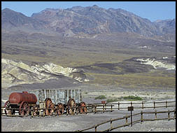 Constructed from piles of rocks, many so-called hunting blinds together with bighorn sheep bones have also been found near springs in the Death Valley region, especially on its eastern side. In ancient cosmological thinking, springs represent not only essential life-giving oases in the desert but also portals leading to the spirit world. In addition, a number of serpentine rock alignments and circles have been discovered in this area, possibly corresponding to water and the underworld. [Charles B. Hunt, Death Valley: Geology, Ecology, and Archaeology, p. 173] The existence of at least one documented bighorn sheep petroglyph (but probably more) in Titus Canyon in the Grapevine Mountains attests to the fact that the Bighorn Shaman's powers to control weather were needed throughout the entire Great Basin. [Whitley, op. cit., p. 85] Although hunting of mountain sheep undoubtedly occurred, more likely the emphasis was on their supernatural attributes connected with water. [James R. Cunkle and Markus A. Jacquemain, Stone Magic of the Ancients: Petroglyphs, Shamanic Shine Sites, Ancient Rituals, p. 111]
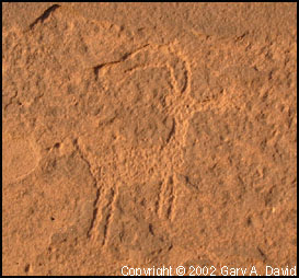 The Hopi constellation named Soo'ala literally means "star-horn," which very possibly could refer to Aries the Ram. The word soo'ala also refers to a cat's cradle figure, whose angle of strings could be likened to the constellation's angled ram's horn. However, as with the case of the Gemini Twins, Aries does not resemble a ram or ram's head in particular, but only symbolically so.